Kashipur-Ramnagar-Ranikhet-Kausani-Baijnath-Bageshwar-Chakouri
Day 2 (Thursday):
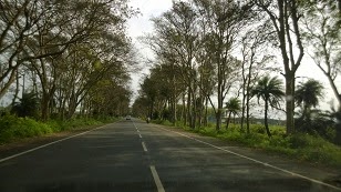
Smitten by driving through bad road, we started enquiring at
the hotel’s reception desk about the condition of roads before we chalked down
our travel plans for the day. We decided to drive to Ramnagar, the base of the
hills, 27 km from Kashipur. We set out on the road by 8:30 am. The drive was
very refreshing; roads had scant traffic and devoid of heavy vehicles. Green
vegetation along the sides of the road appeared more tender and beautiful. With
the onset of spring the budding foliage on the small bushes along the hedges
was brimming with life. The tall trees gently swaying along the wind brought
about new freshness and vibrancy.
Ramnagar, the tourist town, gateway to the hills and the Jim
Corbett National Park is bustling with activity. From Ramnagar we began to feel
the ascent along the hilly terrain and it was drizzling, but very soon rain
stopped and skies have become clear. Our next destination is Ranikhet 94 km
from Rampur. On the way to Ranikhet, we stopped at the Amba Devi Temple few
meters before the famous Garjiya Devi Temple @ Garjiya to enjoy the pleasant
and the calm hilly tracks. Garjiya village is on the outskirts of the Jim
Corbett National Park. The famous temple of Shakti or popularly called Garjiya
temple was constructed on a huge rock in the Kosi River and very popular among
the devotees. As we moved along the road, we crossed the Jim Corbett National Park.
Little ahead of the park, the road was almost chipped away by a stream flowing
over the road. Ramnagar to Ranikhet road is very narrow and almost desolate
except for so few trucks.

The drive through the Mailani ranges was very pleasant.
Except for few isolated resorts scattered within few kilometres distance from
Ramnagar, there was no traffic. It was quaint journey, very peaceful but as
mentioned earlier, roads are narrow and little bumpy. Certain stretches of the road till Mohan are
cracked. But they are drivable, beyond Mohan to Dhanghadi, road is very windy
and the expertise and patience of driver are put to real test. From Dhangahadi,
it is a single road and it ascends slowly. The person behind the steering wheel
is on tenterhooks cautiously watching out for traffic coming in the opposite
direction. There were varied patterns of vegetation across these ranges. As we
hopped on from one hill to another we could have a glimpse of the villages
spread out in the Ram Ganga valley. The awesome pattern of the step cultivation
along the inclines of the hills is very beautiful. The dense vegetation along
jungle ridges near Chiliakula had partly cut off the penetration of sunlight too.
We came to know later that this route is less travelled and explored. The
villages lying along this route were cut off from the overwhelming
urbanisation. People too were laid back and conceited with their sustainable
livelihoods.

People usually prefer to reach Ranikhet via Nainital route
which is 50 km longer. While the level of difficult in driving along this
terrain was high, it is worth the adventure as we had ample time to assimilate
the serenity of the cooler climes. As we started reaching higher elevation we
were very eager to have a look at the Himalayas so we stopped in Totam which
had a platform for Himalaya Darshan but to our grave disappointment, the skies
were very cloudy and snow capped peaks were not visible. We continued our
journey and at a toll booth near Tarikhet, we took a left turn to bypass the
Ranikhet town.

View of a Village
Ranikhet is located at an elevation of 6100 ft, is the
headquarters of the Kumaon regiment. The Kumaon Regiment quarters are spread
across the entire town. Earlier Ranikhet was under Nepalese rule, but the
Kumaonese with the help of the British won it back in 1816 and from then it continued
to be a part of India. The Jhula Devi Temple dedicated to Maa Durga and Chaubattia
Gardens, the two important tourist attractions are distantly located from the main
town. During our drive we didn’t enter the town and instead we bypassed it by crossing the outposts of Kumaon
regiment headed towards Kausani.

From Ranikhet we had to descend a hill to travel towards
Kausani along NH 87 E and crossed river Gagas Bridge. A right turn at the
bridge will take us to Kausani and left turn leads to Karna Prayag. Along the
Gagas River basin we passed through many villages. Agriculture being the main
occupation several acres of the river basin is under wheat cultivation. It is
interesting to find most of the houses had a standing crop of Wheat in their
back yards. Surprisingly all the farm labour and cattle grazing activities were
managed by women folk. The drive from Ranikhet to Kausani was excellent and
ideal. The impeccable greenery a sign of prosperity and wellbeing of the region
seem to emanate some positive vibes. We felt rejuvenated and energised by this
luxurious green belt. Road was wide, without sharp bends or curves and gradient
along the hills was not very steep. Meanwhile we stopped at Someshwar for
Petrol and the owner warned us that we will not be able to find another filling
station till Bageshwar (or for the next 60 km). Till then we didn’t realise how
difficult life in hills could be. Interestingly, while distance in regular
parlance refers to the linear distance between two places but across the hills,
it has two dimensions, the elevation and the linear distance.

Kausani is 59 km from Ranikhet and since we wanted to reach
Chakouri by night so decided not to visit any tourist attractions located
within the town. Impressed by the picturesque beauty of Kausani Mahatma Gandhi
called it Switzerland of India. Anashakti Ashram the place where Gandhiji spent
time writing a commentary on Anasakhti yog in Kausani is a highly revered
place. It is quite popular for its scenic splendour and its spectacular panoramic
view of the Trishul, NandaDevi and Panchachuli Himalayan peaks. Located atop of
ridge of 6200ft elevation is enveloped by the dense pine forests and overlooks
the Someshwar valley on one side and the Katyuri valley on the other is an
ideal place for honeymooners. Kausani is also known for its Tea gardens. People
flock to this hill station to have an unobstructed view of the Himalayas. It is
a leisurely place with few local attractions. The recent unseasonal rainfall which created havoc
in the Northern part of India has spoiled our travel plans in part as the
cloudy skies reduced the visibility of the mountains from Kausani. Though
little disappointed we drove along the road leading to Baijnath 16 km away through
Garur the popular twin cities of this region.
Baijnath is a historical town and derives its name from the
deity Vaidyanath, the Lord of Physicians an incarnation of Lord Shiva. Baijnath
temple dedicated to Vaidyanth was constructed by the Katyuri Kings, the local
Kumaon Kings in the around 1150 BC along the banks of the river Gomti.
According to Hindu Mythology, it is believed that Goddess Parvati married Lord
Shiva at the confluence of Gomti and Garur Ganga. The temple complex was built
with stone in Nagar Style. Besides the main temple of the Vaidyanath, there are
17 other subsidiary temples of Kedareshwar, Lakshmi-Narayan and Brahmini Devi
in this complex. It is now declared as UNESCO world heritage site. Domes of
some of the temples have collapsed due to earth quakes. The main attraction of
these temples is the stunningly beautiful idol of Goddess Parvati with tresses
of 26 miniature images around it. Baijnath was the capital city of Katyuri
kings and was referred to as Kartikeypura before the construction of the
temple. Just lying next to calmly flowing waters of river Gomti, the temple is idyllic
symbolising the glory of the Indian civilisation of those years. After the
darshan of the deities in the temple complex we resumed our journey along the
Baijnath-Bageshawar road.

Baijnath Temple
Bageshwar is 28 km away from Baijnath and we passed through
several villages during the drive. The drive through the Katyur valley is so
fulfilling and amazing. As we were
driving deeper into the hills, the mystic hues of Nature’s began to transcend
our souls slowly cleansing us of our expendable stress and tensions reposed by
urban lifestyle. Bageshwar is a vibrant town with lot of activity as it is the
most prominent tourist centre of this region. It is the base camp for trekking
to Pindari, Suderdunga and Kafni Glaciers and famous for the old Bagnath
temple. Located at the confluence of the Gomti and Saraju River it has so many
prominent temples in its vicinity. Again stocking Petrol from filling station
we moved ahead towards Chakouri, our night halt.

April in general is
considered as the ideal time to visit hills. But the untimely rains have played
a spoil sport with cloudy skies obstructing the view of beautiful Himalayan
peaks throughout our drive so far. Firmly determined to have a glance of the
majestic mountains we logged onto the NH 309A, Bageshwar-Chakouri route. As
dusk is slowly setting in we wanted to reach Chakouri, 53 km away before it
becomes very dark. The picturesque setting of the Bageshwar town in the valley
as we ascended towards the NH309A was awesome. The drive was through forests
comprising of the tall Pine trees was very pleasant. Since full moon day was a
day ahead, the exciting drive at dusk under the radiant bloom of moon was
delightful. Road was in good condition except for occasional bad patches where
waterfalls were flowing over the road. We slowly drove along the hill and
reached Chakouri by 7:45pm and checked into a modest inn, Hotel Him Shikar
since the KMVN (Kumaon Mandal Vikas Nigam) Guest House is undergoing a major
renovation. KMVN is supposed to offer a splendid view of the Himalayan peaks.
After savouring piping hot onion paranthas, rotis and aloo jeera we retired to
bed and prayed Heavens for a bright sunny day.
Photographs Courtesy: Dr. T. L. S. Bhaskar
Photographs Courtesy: Dr. T. L. S. Bhaskar
@ Copyrights reserved.
No comments:
Post a Comment